The population density in urban cities of nepal is growing rapidly, which increases traffic. This implies a growing demand to adapt and implement sustainable green public transport. The share of motor vehicles powered by natural gas and electricity must increase in order to further reduce environmental impact of motor vehicles. Electric city buses and long distance buses will have a large impact on air quality and noise climate. Nepal must soon develop and transition to a new strategy for green vehicles – this can be made within a program for sustainable car traffic and monitor technical development within the field of vehicles and renewable fuels. Government must act to developing following policies:
1. Public Transport should be managed by the local government.
2. Local governments in collaboration with the private sector can jointly invest for the public transport operations.
3. Public transport should be operated through a company (investment from public and private) with integrated planning, ticketing and time-table.
4. Local government should bring rules and regulations to facilitate the operations of public transport.
5. Local governments should be ready to provide subsidies to make public transport sustainable, reliable, safe and secure.
6. Need to formulate strategies to promote people to use public transportation.
7. Proper public transport will encourage people to shift from private vehicle to public. This will ultimately reduce vehicles on road, hence will ease traffic movement.
8. Implementation of proper public transport will promote motorcycle users to shift from motorcycle to public transport reducing traffic accidents.
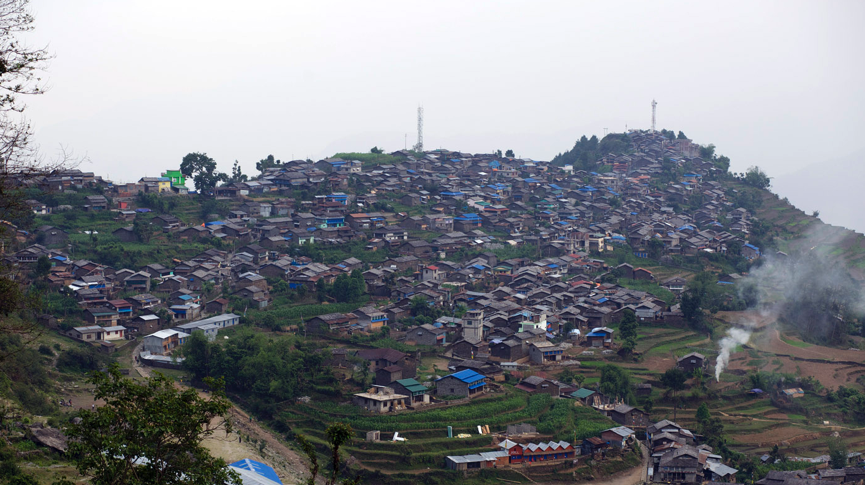
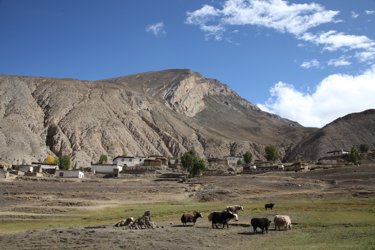
In the early times when Nepal was divided into many states, Barpak was ruled by the Ghale king. The majority of the people living in Barpak are Ghales and Gurungs with a minority of Sunars and Pariyars. The houses are built up of stones. Barpakis have a deep relationship with culture and nature is hard to find anywhere else. Barpak also offers a perfect home-stay experience besides a jaw-dropping landscape of snow-covered mountains.
To celebrate the Barpak Epicenter memorial week as there was the epicenter of the massive earthquake on 25th April 2015 of 7.9 magnitudes and many houses collapsed and many died), the local Community of Barpak will organize Earthquake Memorial Week, with the following s events:
Memorial Day: 25th April is celebrated as memorial day. The memorial Assembly will be followed by a Candlelight Ceremony.
Art and Culture: This includes folk dances such as Maruni, Chutka, Jhaure, Kauraha, etc. Typical cultural dresses and music.
Food Market: Alum which is made from Millet, pickle of Gundruk Selroti, Popcorn, pop soybean, tea/coffee, bread from Wheat, Millet, and Buckwheat.
Local Games: Promotion of local games such as Hadi Futai, Cock Fight, Laddu Nachai, Dandi Biyo, Beda Judai and so on.
Barpak MTB XCO Challenge
The first Mountain Bike World Championship was held in 1990 A.D. The mountain bike became an Olympic Sport in 1996 A.D. The 14th Asian Mountain Bike Championship was organized by the Nepal Cycling Association in 2008 A.D. The competition was held in Chobhar hill of Kathmandu. The category of the championship was cross country type and the event was supported by Union Cycliste International. Among the various categories of Mountain Biking races, MTB XCO Challenge is one of the popular races these days.
Barpak is a mind-blending intense venue brimming with colors, culture, and scenic wonder where we can host an MTB XCO Challenge to promote eco-tourism in Barpak.
Barpak MTB XCO Challenge will be five laps of 5km that includes the route which passes through the alley of the Barpak, jeep track, and single track. The route also includes Mud-road, staircase, and paved stone. The village perched on a hillock on the lap of Manasalu Mountain range lies about 1900 meters above the sea-level.
About StoryCycle
We have organized StoryCamp in Barpak in 2014 followed by BuildCamp after the 2015 earthquake. StoryCycle has facilitated Barpak’s electrification and has economically and socially transformed the village. This transformation has encouraged young people to return to the village and start new ventures. This wouldn’t have been possible without the electrification of the village. We have conducted StoryCamp of Barpak to empower media enthusiasts to identify, collect and present multimedia stories, to bring stories, and to increase the digital footprint of the location. We have also facilitated the citizen effort to rebuild Barpak. The purpose of the BuildCamp is to promote the building process of an area by facilitating interaction between communities and subject matter experts including designers, architects, geologists, and anthropologists among others ensuring the incorporation of cultural and socio-economic aspects into the physical infrastructure construction.
Nepal Cycling Association
Nepal Cycling Association is a member of the Asian Cycling Confederation (ACC) and a Member of the Confederation of the International Cycling Union – Union Cycling International (UCI). Nepal Cycling Association is the apex body of Cycling activities. There are 23 district cycling Associations in Nepal.
Barpak Friendship Society
Barpak Friendship Society was established in 2002. It is located at Barpak Sulikot Rural Municipality ward no 2 of Gorkha District of Gandaki Province. The organisation is a community approach to develop their places.
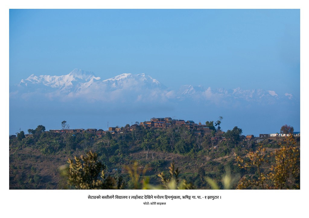
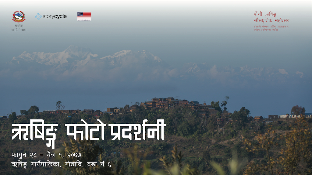
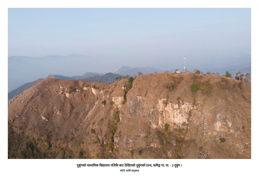
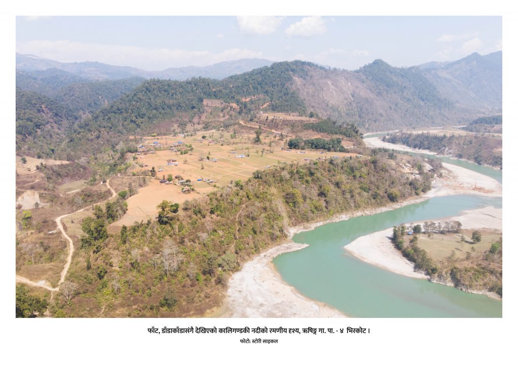
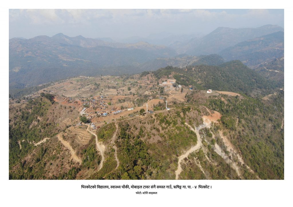
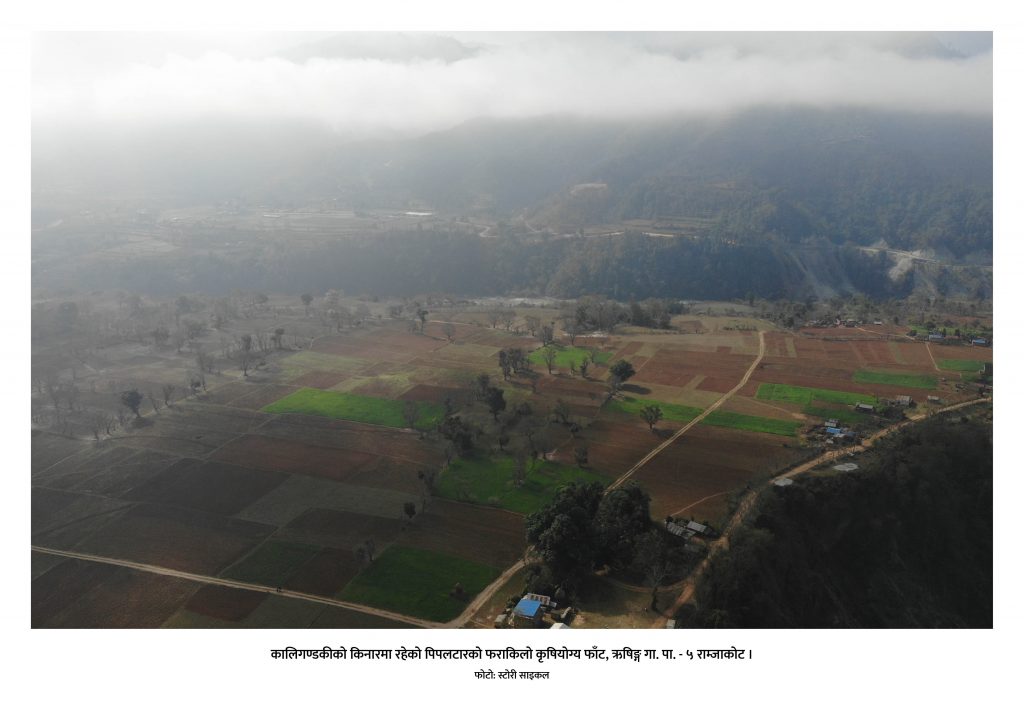
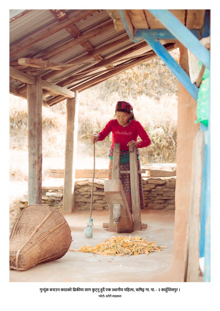
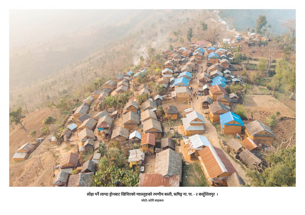
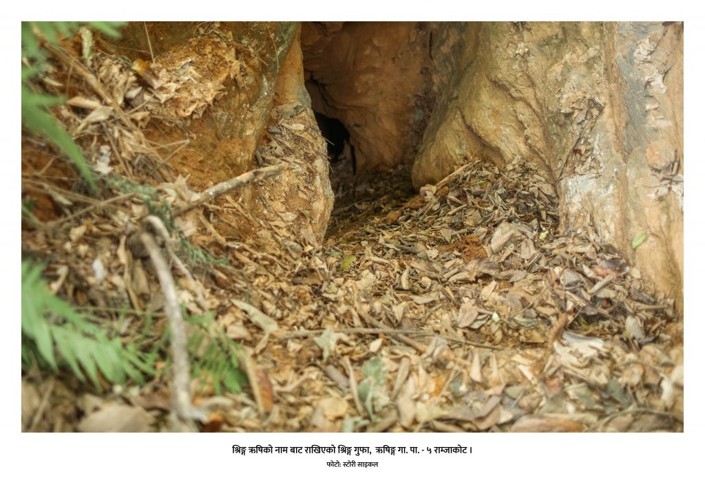
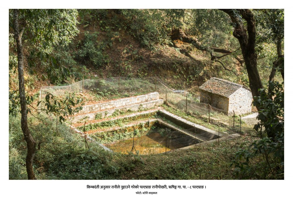
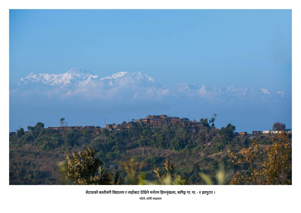
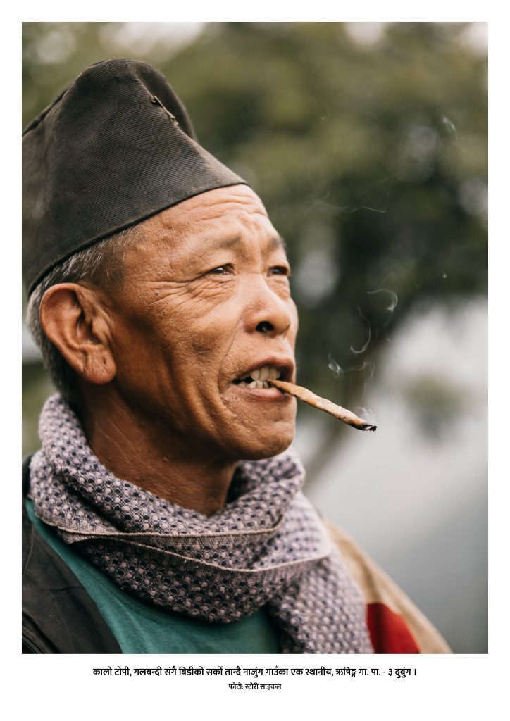
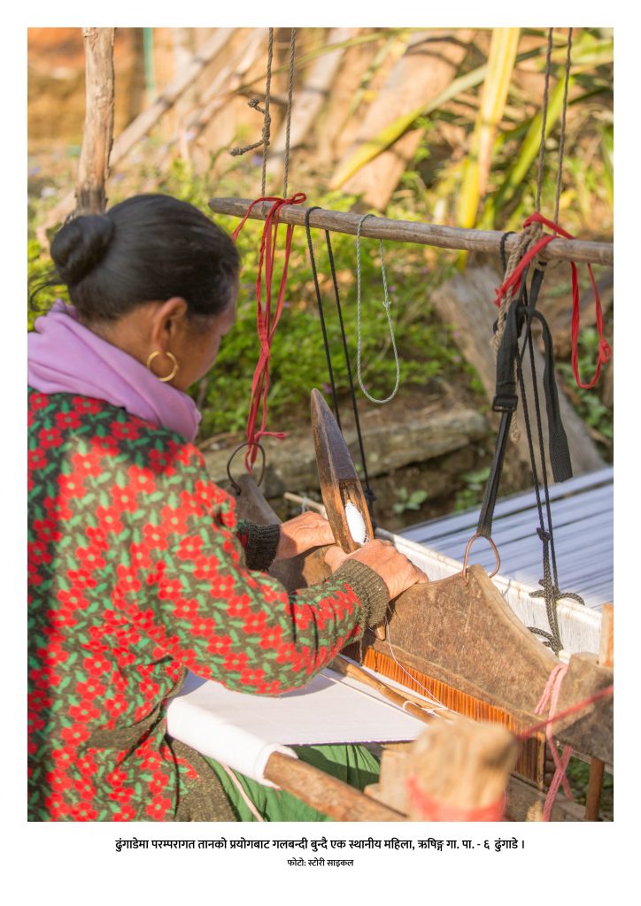
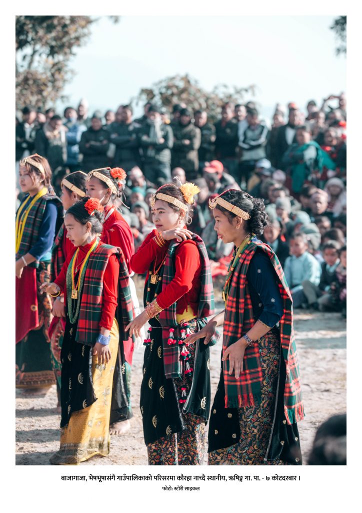
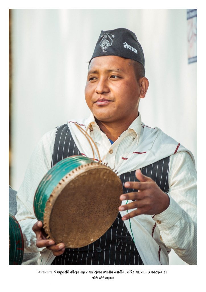
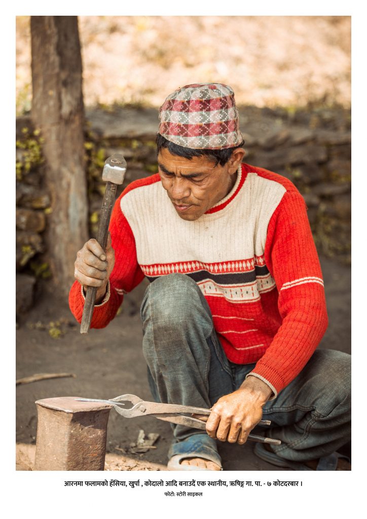
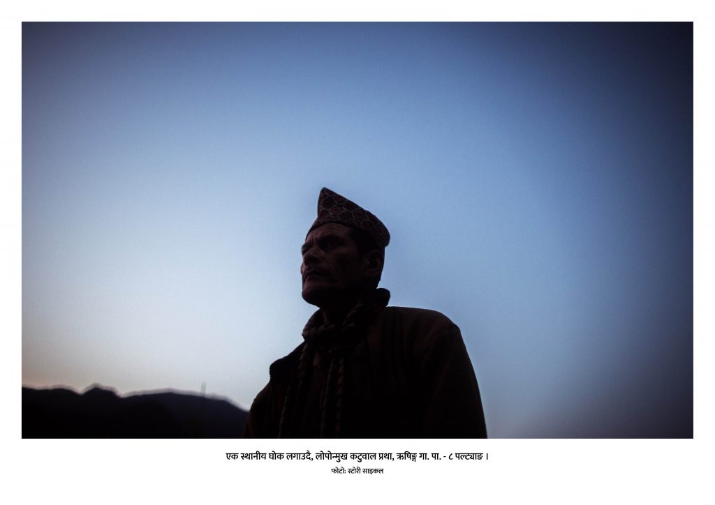
ऋषिङ्ग गाउँपालिकाको ८ वटा वडामा स्टोरी क्याम्प र म्यापअप क्याम्प गरी त्यस वडाको विविध सम्भावना र चुनौती संकलन गर्दा तीन विधाहरु कृषि, पर्यटन र कला-संस्कृतिमा वर्गीकरण गरी ती विधाहरुलाई गहिराइमा बुझ्न सहज बनाउन यो ऋषिङ्गको भर्चुवल फोटो प्रदर्शनी गरिएको हो।
कृषिप्रणाली
कृषि व्यवसाय तथा पशुपालन गर्ने कृषकहरूलाई निर्वाहमुखी कृषि प्रणालीलाई व्यवसायमुखी कृषि प्रणालीतर्फ रूपान्तरण गर्नका लागि कार्यक्रम सञ्चालन गरिएको छ।
पर्यटन
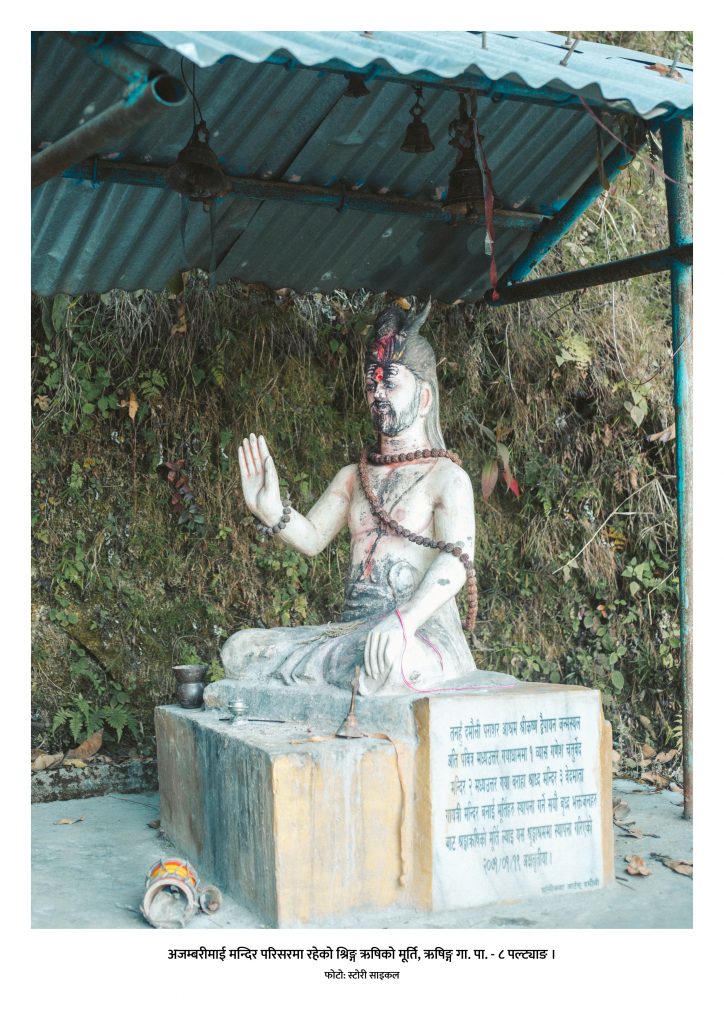
स्थानीय कथन अनुसार सत्य युगमा यस क्षेत्रमा श्रृङ्ग ऋषिले तपस्या गरेको हुनाले यस क्षेत्रलाई ऋषिङ्ग क्षेत्रको रूपमा चिनिने गरिन्छ। साथै नेपाल स–साना बाईसे चौबिसे राज्यमा विभाजन भएको बेलामा कोटदरबारमा मुनि मुकुन्द सेनका भतिजा समसेनले राज्य गरेको कारणले कोटदरबार नाम रहन गएको किंवदन्ती छ । यसै किवंदन्ती अनुसार यस गाउँपालिकाको नाम ऋषिङ्ग गाउँपालिका राखिएको अनुमान लगाउन सकिन्छ । यसरी यस गाउँपालिका भित्र भिर्कोट दरवार, गडगडेश्वर मन्दिर, दुबुङ्गको कोट र दरवार लगायत विभिन्न मठ मन्दिरहरू तथा गुफाहरू रहेका छन् । ऐतिहासिक पुरातात्विक सम्पदाहरूको संरक्षण, सम्बर्धन एवम् प्रचारप्रसार गरिएको छ।
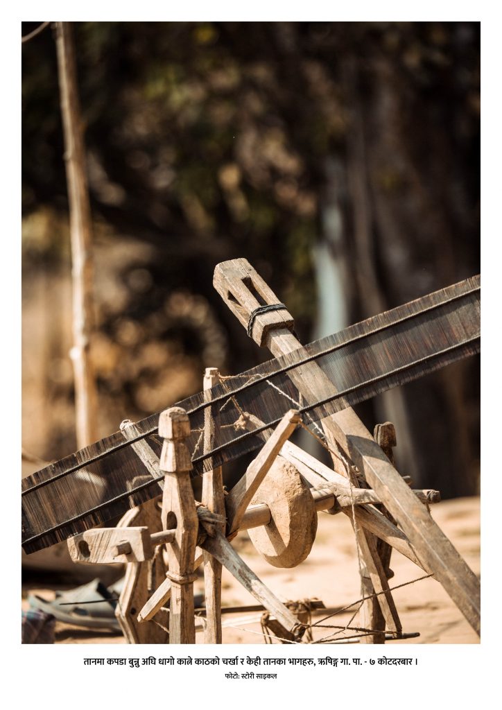
कला-संस्कृति
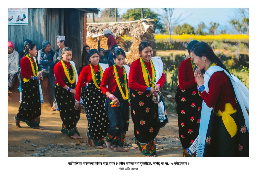
स्थानीय संस्कृति संरक्षण तथा सम्बर्धनमा समुदायको सहभागितालाई अभिवृद्धि गरेर कौरा नाँच, सोरठी नृत्य, झ्याउरे, पञ्चेबाजा, लाखेनाच, मारुनि नाँच लगायतका विशिष्ट साँस्कृतिक सम्पदाहरूको संरक्षण, सम्बर्धन एवम् प्रचार प्रसारका लागि बिशेष पहल गरिएको छ ।
Enhancement of the online presence of domestic locations in the tourism market is always crucial. To enhance the online presence of different locations, we have collaborating with locals, policymakers and experts and tried to lay a foundation for e-readiness of the location.
Dharche, Gorkha of Gandaki province possesses tremendous potential for tourism development because of its unique natural and cultural heritage. There was an essence to enhance its online presence. In an effort to increase and enhance the digital presence of Dharche we conducted various side events on digital storytelling, mapping, photo Exhibition via photonepal.travel, the official photo-sharing platform of Nepal Tourism Board etc. By combining this information, we carried out our packaged program Virtual Heritage Tour.
Dharche Rural Municipality is located in Gorkha District of Gandaki Province, which is home to a number of traditionally animist indigenous communities. The name of the Dharche Rural Municipality is named by the combination of two words “Darj” and “Gang”. Dharj means flag and Gang means hill. This is in reference to the tradition of installing prayer flags on hills and in the rivers for the well-being and success before travelling out of the villages. The natural heritage present in Dharche has a vast potential in the tourism industry.
Dharche is surrounded by China and Dhading district at the East, Barpka Sulikot RM at the West, Chuma Nubri RM at the North and Arughat RM at the south. Made up of 7 wards, it has a population of around 13 thousand 200.With much potential in hiking, there are three most popular hiking routes in Dharche. Those are Rubina-la trekking, Manaslu trekking and Ganesh Himal trekking.Today, we will be following the route shown on the screen. From Kasigaun to Ganesh Himal Shyalka Pass, we will end our journey in Tatopani, bordering China.Our journey starts with a 5-hour ride from Kathmandu to Dhading to Kasigaun.
Kasigaun
Kasigaun holds a religious and historical significance where you can experience its diverse nature, culture and tradition. Gondo of Kashigaon, a relic of Gosya Ghale King’s Fort at Gondo Danda is a historical place. Manaslu Himal, Boudha Himal, Silinga Himal and Arughat valley of Dhading district can be seen from this place. From the tourism point of view, Dharche has canyoning and rafting potential and Kasigaun can be one of the places.
Maane Dance – Kasigaun
Maane Dance also known as Tara Devi puja is usually done in the rainy season when the villagers bring home their ripened crops. To stop the mice from eating crops and seeds, Mane Nach (Jatra, Mela) or Tara Devi is worshipped in the month of November/December as well as the deities of the village Kalchang Devi, Lamaguri Devi and Manju Devi. It is believed the mice will run away when the dance takes place and Tara Devi is worshipped. The deity at the temple, Tara Devi, is brought home and worshipped for the whole night. When taking Jewel(Mane) from their home, Lama worships and recites the Tibetan book along with Lada Tormo. The next day, a boy and a girl are dressed and the Lama recites the Tibetan Vedha and worships the jewels(Mane). While the worshipping is going on, no one from the village is allowed to farm for 3 days. The Lama concludes the ritual by giving a blessing to all the villagers.
Hyursha Devi Puja
Hyursha is another ritual conducted in the village. On that day, Thorong Phirphire is placed on a long piece of wood and rotated when the wind blows and the figures of various animals are drawn from flour and worshipped through spiritual means. Once done, the leaves of different types of trees are burned to repel insects. This process is known as Singne Polne. It is customary to perform this ritual before planting corn seeds and villagers believe that insects like grasshopper and hailstorm will not destroy their crops.
Maruni Dance
Another famous dance of Kasigaun is Maruni Nach which occurs around October/November where goddess Durga and Saraswati are worshipped. Two boys are draped in a girl’s dress and dance while the goddess is worshipped.
PungulChet
As we move ahead from Kasigaun, we reach a place called Pungulchet. We can experience the beautiful scenery of Ganesh Himal as we move along the route.
BongorChet
The next stop from pungulChet is BongarChet. We get to see even better scenes of Manaslu and Boudha Himal than from Pungulchet. Second Night of stay is done in this mountain in a camp under the mountains.
Birim Dada
Birim Dada is our first viewpoint once we pack our tents and move ahead with the trek. Runchet Valley and Ganesh Himal two and three can be clearly observed and you cannot do anything but keep staring at the mountains. You can also see trees full of rhododendron, the national flower of Nepal. Dharche is also popular for its fauna and flora such as Laliguras, Sonpati, Nirmasi, Dhupi, Padam Chal, Panchaule, Aallo and Yarsagumba – half fungus, half caterpillar.
Shyalka La Pass
Then comes the pass the route was named after. Ganesh Himal Shyalka La pass. It lies in between two hills Mandra and Myugachet Kharka and takes about three to four hours to cross.
Myugachet Kharka
Once we reach the other side of the pass, we come to a place called Myugachet Kharka.It is needless to say that Ganesh Himal is visible.But one of the interesting stories told by the forefathers is there used to be diamond and pearl mine.No study and research are done regarding this matter till this date.
Ganesh Kunda
There is one historically significant place just one hour away from Myugachet Kharka and that is ‘Ganesh Kunda’. Locals wash their cattle with the lake water to prevent harms. The place is so remote that even some of the locals do not know much about the place.
Runchet Village
Runchet Village is located approximately 50 km North from the district headquarters of Gorkha. The village is situated at 1750m from the sea level. It is believed that the ancestors came from Tibet and settled. The Runchet village was established with the name of Rukchet earlier but now it is recognized as Runchet. The Runchet Village is surrounded by historical and touristic places like Kamlakot, Budhi Gandaki and Manaslu Himal from the North, Kerauja from the South, Ganesh Himal, Kalopokhari and Runchet river in the East and Dharche Danda in the West.
Mane Dance
Mane Dance, which we talked about at the beginning, is also celebrated here in the first/second week of December but in a slightly different manner. It is said by the Lamas that the dance originated 1000 years ago. Spiritual practices were performed to avoid the extinction of their offspring, they planned to establish a Mane at their place, So they called Chhtup Gyatup Lama from Yarsa or the Jianjing and established Mane.
Runchet Canyoning
Runchet river has a huge potential for canyoning. Here, Canyoning sport ranges approximately 11 km. 76 waterfalls have water canyoning possibilities among which 65 are long-range.
Kamla Fort
Kamla Fort is situated North of Dharche ward 2 Runchet Village. During the Historical ruling period of Baise Chaubisi Rajya, Runchet was ruled by a Magar King who was later murdered using stones as weapons and thrown in the Tatukuna rivulet which was named Rutwang Khola. The forefathers of the Magar community refused to drink water from the river, as it was mixed with their king’s blood. Artefacts currently present at the fort are Stone for sharpening weapons, resting places, the foundation of the fort and training spots of the military.
The Ghale kings ruled Dharche during the power of Baise Chaubise Raaja, which is why we can find many forts like Bhirkot, Kumpa kot, Khorla kot along with Kamlakot.
Black Lake (Kaalopokhari)
There is a famous lake in Runchet which goes by the name Kaalopokhari, also called Pokarchet Cho Chho is situated 3467m from the sea level. This place is promoted as a viewpoint as all wards of Dharche rural municipality. From here we can observe Ganesh Himal, Srerenge Himal, Manaslu Himal, Serere Peak and Boudha Himal.
Kerauja
We have now reached Kerauja. Kerauja is one of the largest villages of Dharche. Destroyed in the 2015 earthquake, the whole villagers had to migrate to another destination nearby.
Naara Festival
Nara festival of Kerauja is organised to protect crops, animals and humans from illness. Different kinds of dance are performed such as Yak dance, Horse dance, Kusunda dance and Chyaam dance. The locals believe that if the deities are not worshipped, the village stuffers from droughts and other natural calamities.
Semjong Taal
Semjong Lake is an ancient lake situated at the height of 2720 meters. The speciality of the lake is that it does not dry even during drought. It is believed that if the lake is worshipped during the drought, rainfall occurs.
The shamans enter the lake and worship it and ordinary people cannot enter the lake as it is not possible for them to exit the lake due to its spiritual powers.
Sansar Devi Puja, Malgi Dada
Sansar Devi puja is done at Malgi Dada of Kerauja. It is worshipped on the month of may at malgi dada to prevent spread of epidemics in the village. Animals are sacrificed for this occasion. Malgi dada is famous as a picnic spot, apple and potato farming and has potential for paragliding sports.
Cantilever Bridge
Moving on from Kerauja, On the border of Dharche and Northern Gorkha, villagers were cut off from other places due to the landslides caused by the 2015 earthquake. The cantilever bridge, a first of its kind in Nepal, was built by the engineers anchoring the structure to the rock face with special bolts drilled to the rocks. The restoration of these pathways opened secure access to the Tsum Valley and villages in northern Gorkha for the local people as well as trekkers in the Manaslu Conservation area.
Tatopani
We are now at the final point of our route, Tatopani. Dharche has an abundance of hot springs all over the Rural Municipality, especially around Tatopani where Budi Gandaki Khola flows through. Recently, around 2 weeks ago, Dharche Rural Municipality organized their first official rafting program in Budhi Gandaki river. Just 2 hours away from Tatopani lies Tatopani Kunda, hotspring. Washing off at these springs is believed to furnish good health.
Chung Kang (Bhirkot)
Bhirkot is famous for the Epicenter adventure cycling trail Which perhaps could be the first-ever trail made for cycling in the country. The trail begins from Barpak following the route of Darche’s Gupsipakha-Gumda-Chungkang up to Machhikhola. The trail which is 16.2km is most suitable for downhill racing and some have hiked up to the hill as well.
Harry Hill
The devastating earthquake of 2015 swiped away many houses in Dharche. British Prince Harry provided grants for the reconstruction of a school in Lapu Besi and was involved for 21 days. Impressed by his humanitarian action and contribution, the locals renamed the Tambu hill as Harry hill.
Laprak Community Village
Laprak Community Village is another attraction of Dharche. After the 2015 earthquake completely destroyed the village, Non-Resident Nepali Association (NRNA) has been constructing the houses in the village building over 600 houses. The top repetition view of houses has made this a tourist destination.
Ruby Valley
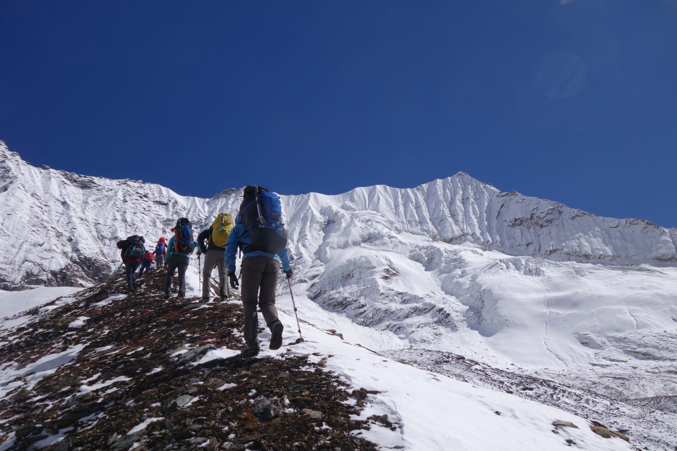
Ruby valley is named after Rubinala Glacier which is 3450 meter away from the sea level and has huge untapped potential due to its wide range of unique biodiversity. The already established Langtang trails around east of the Ruby valley overshadowed the region and are waiting to be discovered by the trekking industry. Natural beauty with amazing waterfalls, flowers and rushing streams and rivers, the trek is considered difficult and crossing glaciers with many crevasses cannot be taken lightly.
Dharche Hill
Dharche Hill might be the most delightful place to visit while you are in Dharche. Filled with rocks and forest, Various water sources and caves can be found around the Hill and has been a contribution to livelihood for many. This is also a perfect spot for bird watching as more than 300 species of birds are found here. Along with Dharche hill, places like Khorkan, Sirkhet, Syokak and Nauwan Jungle, Unchakola, Sacho Dada, Chasdan and Hulma Danda are also famous for bird watching.
Nisharang Chchho Lake
Nisharang Chchho is a higher altitude lake that lies in between Dharche Gaunpalika and Tusm Nubri Gaunpalika. Nisharang Chchho is a local name given by the community people and this lake is also known as Dudh Pokhari and this lake’s altitude is 4700m. This lake is worshipped as a God in the month of August. The locals believe that infertile couples will be blessed with children worshipping the lake and If the lake is visited by people who have sinned or if loud noises are made around the lake, the lake gets covered with clouds.
108 Water springs
108 water springs of Netungo hold an ancient historical significance besides its natural beauty. It was believed that 5 Pandava brothers who were on their way to paradise meditated in the Netungo cave after cleaning impurities in those springs.
Corn Marriage (Makai Bibaha)
Corn Marriage is definitely one of the most interesting rituals out of Dharche. This is performed mainly in Laprak village just before corn seeds are planted in the month of January. Unlike people getting married, two corn are planted together in the field to get married. Religious leaders from the Gurung community decide the time and date of the ceremony and people gather in mass at Laprakwhere the ritual is performed while others dance, drink and eat corn as an offering.
Ghatu Dance
Ghatu Dance is the story of King Pashramu and Queen Yambawati. Dancers enact planting rice and other seeds, hunting and king and queen get married. King Pashramu dies in a battle and the queen immolates herself on his pier, where the dance climaxes. The language of the dance is still unknown and believed to have come from the southern part of Nepal. This dance starts from the day of Basanta Panchami, the arrival of the sprint to the day of Baishak Purnima, until the full moon.
Nauli Chinghar
Lying at the top of Nauli river and waterfall of Lapu Besi, Nauli Chingar is considered and worshipped as a God by the locals. This colossal Chingar is incredible to look at. People of Dharche have delegated it with religious identity making it a religious holy place in the future.
Nauli River Waterfall and Canyoning
Just below the Chinghar, One of Nepal’s hidden gems is Nauli River Canyoning. The refreshing waterfalls, formed among the deep gorges, are perfect hidden havens for hardcore thrill-seekers. The rural municipality recently provided a training camp for canyoning to 20 people along which 7 were women.
Lhoshar
The word Lhosar consists of two words: Lho and Sar. Lho means year and Sar means new year. Each community has its own way of celebrating Lhoshar. The science behind celebrating Lhoshar is the night of 22 December is the longest, and the day begins getting longer from 23 December. Tamu Lhosar is also a celebration of the change in the cycle of time, weather and nature. People celebrate by feasting on delicious food, extending best wishes to each other and singing and dancing to make the day memorable. Carnivals, especially in Hulchuk and Laprak are held every year on this occasion.
Find the press appearances, releases and links about about our programs and activities. If you want regular updates, follow us on our social media pages:
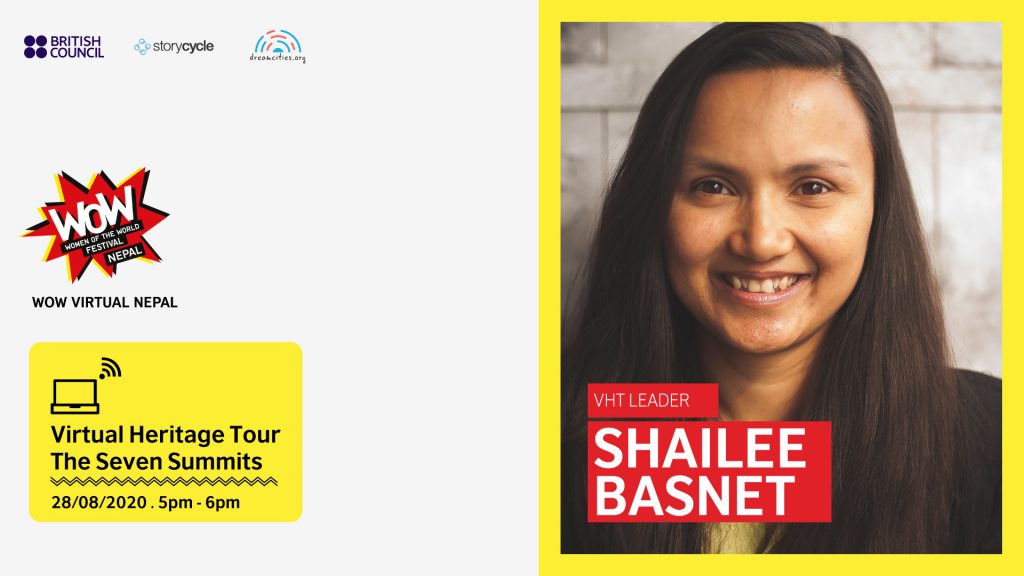
A group of Nepali women mountaineers started their journey by ascending Mt Everest in May 2008. This led them to complete scaling all the 7 Summits by 2014. The group became the first all-women team to do have climbed the seven tallest mountains of each continent.
Our next edition of The Virtual Heritage Tour is ‘Seven Summits’ led by Shailee Basnet. Shailee Basnet, is the leader of the ‘Seven Summits Women Team’ . With her team, she is now leading a program to help train young female survivors of trafficking to become trekking guides. she will be sharing some of the hard-earned insights learned both on and off the mountains.
Friday, August 28, 2020 5:00 pm NPT VHT Leader: Shailee Basnet *This session was conducted in the English Language
Virtual Heritage Tours are a series of digital storytelling that invite tour leaders to take digital audiences on tours of locations around Nepal and the world. The monthly series has taken numerous themes including climate change in the Himalayas and most recently gender through special edition for the Women of the World Festival Nepal’s Virtual programs. Through the VHT series, Story Cycle and the British Council have not only increased the digital footprint of isolated and remote outposts of Nepal but have created legacy documents that are full of expert knowledge about these locations and the challenges they face. It has also enhanced the ability of leading the tours to tell better stories about their work.
StoryCycle provides specially curated experiences, workshops and guided tours in various cities in the country for depending upon requirements, schools, colleges, groups and individuals. We are hosting immersive and diverse events that bring people closer to their local heritage and culture from the beginning.
The British Council complies with data protection law in the UK and laws in other countries that meet internationally accepted standards. You have the right to ask for a copy of the information we hold on you, and the right to ask us to correct any inaccuracies in that information. If you have concerns about how we have used your personal information, you also have the right to complain to a privacy regulator.
For detailed information, please refer to the privacy section of our website, www.britishcouncil.org/privacy or contact your local British Council office. We will keep your information for a period of 4 years from the time of collection.
The Government of Nepal is now transitioned into a federal structure. The demarcation of seven provinces encompasses the induction of many new local governments and city development projects envisioned to support the decentralization of country governance. This recent development presents immense potential to create linkages between multiple stakeholders, especially between citizens and governmental agencies to promote better accountability in processes and projects. At the grassroots level, constructive and continuous engagement can inspire active citizens and authorities to work together for collective gains. Development of localities and places, although mostly instigated by the state, should appropriately account for the diverse perspectives and issues that essentially become the context within which such efforts transpire (often in ignorance of that context).
Need Analysis
Need analysis decides which needs to have the highest priority. It is the difference between the way things are and the way they should be. It determines the facts about the current situation and identify areas for potential improvement. It identifies needs by gathering information. It defines the needs and makes a plan to address them.
StoryCamp
The story camp, with the help of youth leaders will identify such candidates and train them in telling the stories in the most effective manner. The story camp will be conducted to all kinds of stakeholders working in the rural municipality. The participants will be oriented on the methods of better storytelling with the available resources and technologies.
MapUp Camp
Besides, the participants will also be oriented on the mapping up the available resources in the community, such as local business shops, local entrepreneurs and local product available in the community.
Dream Camp
The local communities, Youths and community leaders will together assess what the place was like 10 years earlier and what they want the place to look like after 10 years. The workshop will also link the communities with potential actors that can support in the development of the place. Participants will also collect related stories.
Build Camp
Build Camp is a training series focused on local engineers, developers, local government and leaders to help them plan the structure of their cities. We will facilitate on the design process and make a business plan of that. And the idea will be to collaborate with city planning team.
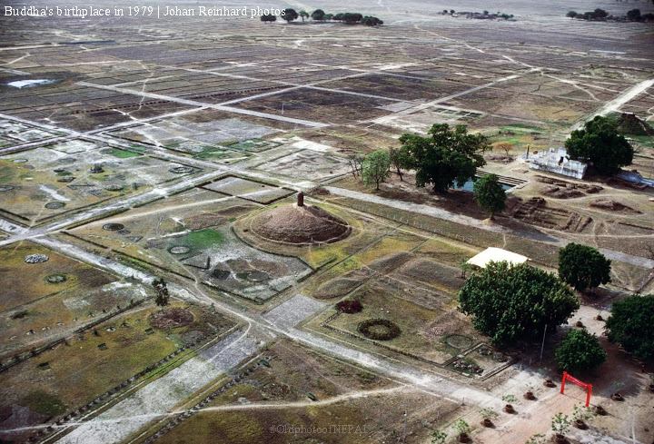
To mark the birth anniversary of the Buddha, people travel to Lumbini for special worship and rituals each year on the full moon day of Baishak to offer their devotion.
Lumbini: Birthplace of Buddha
Mayadevi Temple is the most sacred site in the Lumbini Garden where archaeologists have identified the exact spot where Lord Buddha was born. Inscriptions on the Ashoka Pillar nearby also refer to the spot as his birthplace. The birth took place in the beautiful Sal grove, which is now the focal point of the Lumbini Garden.
Kudan Stupa
The ancient site of Nyigrodharama, now known as Kudan, is another important historical site in the story of Buddha. It is about 6 kilometres from his childhood home at Tilaurakot. Kudan is believed to be the place where Buddha first met with his father, King Suddhodhana after he achieved enlightenment.
Following Buddha’s Path
As a child, Siddhartha the Buddha was troubled by some of the same thoughts that children today have. They wonder about birth and death. They wonder why they get sick and why grandfather died. They wonder why their wishes do not come true. Children also wonder about happiness and beauty in nature. Because the Buddha knew what was in the hearts of children and humankind, he taught everyone how to live a happy and peaceful life. Buddhism is not learning about strange beliefs from faraway lands. It is about looking at and thinking about our own lives. It shows us how to understand ourselves and how to cope with our daily problems.
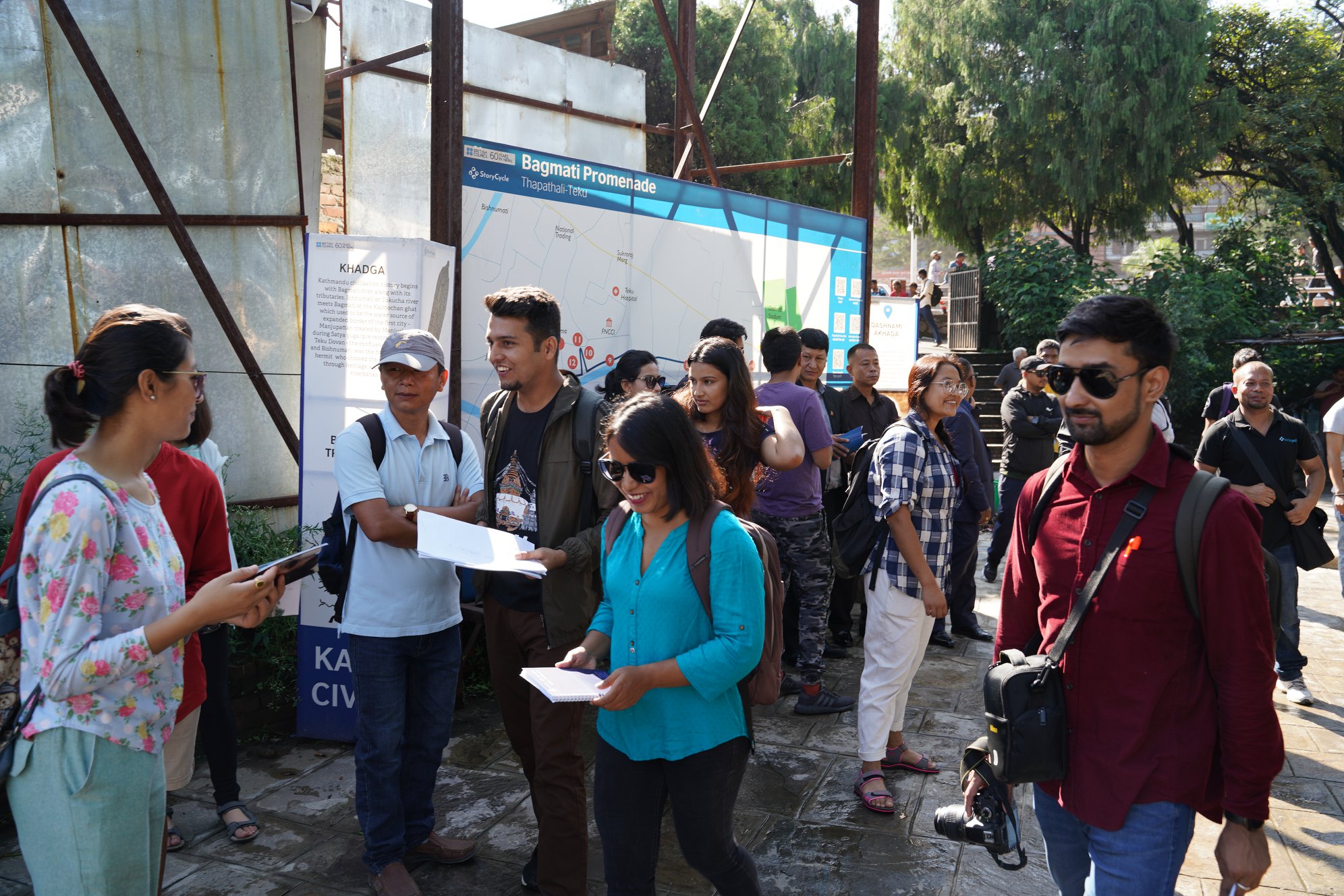
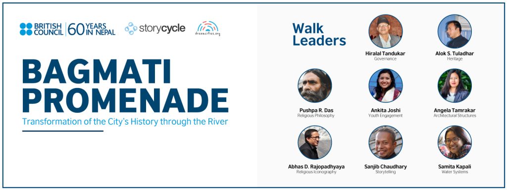
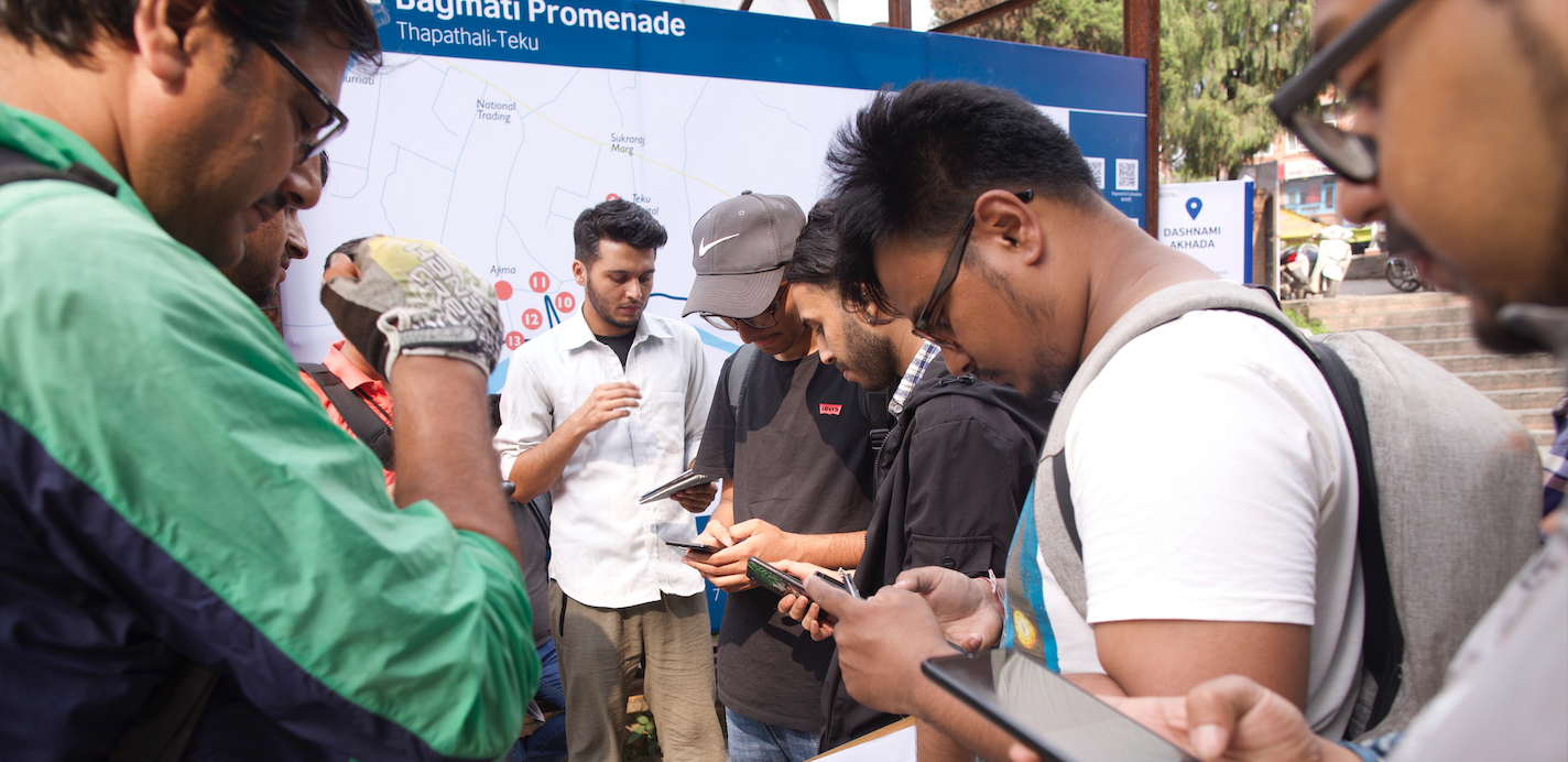
Bagmati Promenade, a historical and cultural walk along the riverbank of the Bagmati from Thapathali to Teku Dovan, has been designed and conceptualised by StoryCycle and the British Council in collaboration with people living and working in the vicinity and/ or having a special affinity to the river.
Bagmati Promenade: Thapathali-Teku
A heritage walk designed by Storycycle with the British Council Nepal in collaboration with Kathmandu Metropolitan City Ward 11 and 12 people living and working in the vicinity and/or having a special affinity.
A heritage walk conducted on 27th July inaugurated by Bidya Sundar Shakya, mayor of Kathmandu was the mega event. The parallel walks were held under themes like Safeguarding Bagmati by Hiralal Tandukar, Storytelling by Sanjib Chaudhary, Philosophy by Chief Priest(Mahant) Pushpa Raj, Heritage and Heritage Mobility by Alok Siddhi Tuladhar and Shriju Pradhan, Environment by Saurav Dhakal, Architecture by Angela Tamrakar, Mapping by Sushil Dhakal and Water system by Samita Kapali.
The Heritage Route
The heritage walk was started from Thapathali Chess-Park through Akhadas, Kalmochan Ghat, Tripurasundari, Chandra Ghat, Puret Ghat, Pachali Bhairav, Teku Dovan and ended at Jagannath Temple.
Youth Engagement in Revitalizing Bagmati
Through these heritage walks, we are aiming at making the local community and commuters aware of the preservation and promotion of culture and natural heritage. These walks will also mobilise the youth, engage and integrate them into the movement for sustainable conservation with the aid of technology. Further, the walks will integrate heritage site monitoring using a geospatial method, over time, as a preventive conservation measure which helps promote the cohesion of cultural and environmental values. Such walking trails in the field of heritage emphasize the preservation of tangible and intangible cultural heritage and provide a wonderful opportunity to understand the history of cities and the cities that have changed over time.
Speaking on the occasion, Hiralal Tandukar, chairperson of ward 11 of Kathmandu Municipality, highlighted the Bagmati heritage and emphasized that the consciousness of youth towards the heritage today and they are always eager and enthusiastic to learn about the heritage.
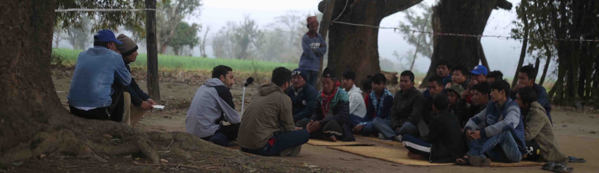
Nepal experienced a major earthquake – with epicentre in Gorkha district’s Barpak – on April 25, 2015, which triggered the huge loss of lives and property, unprecedented in the country’s history. Almost the entire Barpak was flattened, with huge loss of lives and property.
Bir Bahadur Ghale will take us on tour and shared how the Barpak community, the epicentre of the quake, rebuilt Barpak. He explained the steps of the rebuilding process and how they are dreamt to make Barpak a sustainable town in future. Bir Bahadur Ghale is an Ashoka Fellow and energy access entrepreneur based in Barpak, the epicentre of the April 25 earthquake. He is a revered community leader of Barpak where people know him for his work of electrifying the village through a micro-hydro plant in the 1990s. Barpak has constructed several micro-hydropower plants for many communities across the country. After the earthquake, Bir Bahadur Ghale was actively engaged in relief and temporary shelter management in the village. He is now engaged in preparing a master plan for the rebuilding of Barpak.
If you would like to lead a virtual heritage tour, please email us at info@storycycle.com
Dhe is a small village located in Upper Mustang, in Mustang district. Dhe is locally known as Dewa which means a blissful land of Buddha or Sukhavanti in Sanskrit. The locals are known as Dewa. Dewa denotes both people and place. Dhe locals speak Tibetan dialect, known as Lowa which is quite different from Standard Lhasa Tibetan.
Accessibility
We start our tour from Kathmandu, the capital city of Nepal. Dhe is not that far from Kathmandu, it is around 450-500 km away. However, getting it is not easy. First of all, we have to reach Pokhara which takes around 6 hours by land, 25 minutes by air. From Pokhara, we have to travel towards Jomsom, the capital of Mustang district. By land, it takes around 10 hours but by air, it is just 20 minutes to reach Jomsom from Pokhara. To get used to the local condition, you can stay at Jomsom or Kagbeni. There are two locals jeeps going to Upper Mustang every day, but you can also reserve your private ride which takes 7 hours from Jomsom to reach Tsarang and 1.5 hours from Tsarang to Dhe. There is also an ancient trail from Tsuksang which goes to Dhe via Tangya.
Dhe Village
Now, there are 14 families with almost 100 people living in the village. Dhe village follows Nyingma sect of Tibetan Buddhism and there are few families with Bon heritage. Most of Upper Mustang follows the Shakya tradition of Tibetan Buddhism. Villager’s resettlement dream depends upon the success of this apple plantation. These organic apples need a market. Collaboration with Greengrowth to take the first Harvested apples to Kathmandu.
Agriculture
They are dependent on agriculture and animal husbandry for livelihood. Seasonal trade in winter months is also very important for survival. There is only a single crop cycle in the village and agricultural produce is never enough for the villagers to last the whole year. Mostly wheat and barley are grown here. Unlike other higher settlements in the Himalayas, buckwheat doesn’t grow in Dhe. Upper Mustang region lies in rain shadow thus the landscape is mostly barren and dry. Walnuts, peaches, apricot, hazelnut, plum and other few fruit trees are cultivated in Dhe. Apple plantation is supposed to make the transition easier so they are serious about their apples.
Climate Change
Due to climate change, precipitation patterns have changed and pastureland is degrading at an alarming speed. Animal husbandry is not possible due to the lack of proper pasture in Dhe. The acute shortage of water has forced villagers to abandon their fields. Climate change and environmental degradation have depleted water sources of Dhe. Extreme weather and precipitation pattern have changed the local landscape and water system. There is almost no effect of monsoon in Upper Mustang. The winter snow is expected to accumulate and melt in spring months to provide water for the irrigation. But in recent time – snow melts during winter months due to high temperature resulting in flood. The groundwater system almost has no time to charge itself. There is no snow left for spring – so most of the water sources in the region have dried. Agriculture is simply not possible right now in Dhe. There are only 9 families left with a goatherd and just one family of Dhe owns a yak herd now. Yak is expensive and a loss of a single animal can ruin the family’s yearly net income. Degrading pasture is making animal husbandry unsustainable in Dhe at the moment. A small but vital part of income is generated by selling local surplus such as Jimbu, mushroom(s), and other local products in lower areas during winter months. All forms of traditional livelihood in Dhe is affected by climate change.
Every year, the International Everest Day is observed on May 29 that is today. International Everest Day is celebrated in Nepal and other countries around the world to convey the message to the world about tourism, mountaineering expeditions and other adventure activities in Nepal.
Sixty-seven years ago, Tenzing Norgay Sherpa and Sir Edmund Hillary became the first two people to reach the summit of Mount Everest, the world’s tallest mountain.
Culture
For the Sherpas, Chomolungma, as we call it, is a sacred mountain on which a goddess lives. Months before we begin an ascent, we start worshipping and asking for her forgiveness because we have to put their feet on her body. Right before the final steps to the summit, others run to take photos but I or Sherpas bow their head again and ask for her forgiveness. No matter how strong you are, how good you prepare, you have to be blessed by God to reach the summit.
Thame Village
Thame (pronounced “Ta-may”) Valley lies 20 miles west of Mount Everest, in the upper Khumbu region of Nepal. It is the heart of Sherpa country, a string of high-altitude villages stretching from the market town of Namche to the border with Tibet. Chances are that a man chosen at random has climbed Everest; certain is that every villager has lost a relative or friend to the mountaineering industry. Home to many famous Sherpa mountaineers, including Apa Sherpa, who holds the world record for summiting Everest 21 times, It was also a childhood home of Tenzing Norgay who was (with Sir Edmund Hillary) one of the first men to climb Mt. Everest. The guide who has seen the most clients summit, Everest, under his watch is Lakpa Rita Sherpa, also from Thame. Feats of human accomplishment come from here, and tragedy is also a regular visitor.
Accessibility
There are two main climbing routes on Mt Everest namely
Southeast Ridge in Nepal and,
North Ridge Tibet
Here, we are exploring the southeast Ridge in Nepal. The southeast Climbing Routes on Mount Everest route in Nepal was the one used by Tenzing Norgay and Edmund Hillary, who were the first people to get to the top of Mount Everest in 1953.
Difficult points of the Southern Ridge
The Khumbu Icefall is considered one of the most dangerous points on the Everest summit route due to the unpredictability of the terrain. Avalanches are not infrequent, there are hidden crevasses, and large blocks of ice have been known to fall down directly on top of climbers.
The Death Zone of Camp 4 is not one particular area on Everest, but rather any area over 8000m, where there is really not enough oxygen for humans to breathe. At the summit of Mount Everest, most people take in around 30% of the oxygen they would at sea level. As such, a human only used to breathing at sea level could only stay on the summit a matter of minutes before collapsing. The body cannot acclimatise.
Bagmati Promenade, a part of the Our Dream City Campaign, is a heritage walk designed by StoryCycle and the British Council in collaboration with people living and working in the vicinity and/or having a special affinity to it. The walk has been conceived by combining stories from history, religion and social life, and their connection to modern society. Its interest and appeal has unified people and brought in a lot of knowledge in one place.
Walk along the Bagmati corridor from Thapathali to Teku exploring stories like history, religion and social life and their connection to modern society.
Thapathali Chess Park
There is a Chess park between the Thapathali Chowk and the Kalmochan Temple established 30 years ago by Bharat Dhimal from Morang District. Back then , very few people used to come to play chess but now it is producing national chess players as well.
Akhadas
Prime Minister Jung Bahadur Rana built “mini Kashi” for the Hindu pilgrimage visiting Nepal during Shivarati naming them as akhadas outside his once Thapathali Durbar complex which today now lies under the Thapathali bridge. There are four type of akhadas.
Udasi Akhada: Built by Jung bahadur with Badri Narayan statue being installed in temple cum sattal complex. It was renovated in 1935. The chief priest or mahant provide food and shelter to pilgrims or saints or sadhus of this sect when they visit Kathmandu.
Dashanami Akhada: Followers of Sankaracharya are known as dasnami or sanyasis namely saraswati, bharati, giri, puri, thirta, ashra, ban, aryanya, parbat and sagar. Built by Jung Bahadur and restored in 1935. Shivalaya in the center is made by Swami Shivananda Giri in 1991.
Nath Akhada: The temple contain the samadhi shrine (tomb) and gaddi (prayer seat) of Gorakhnath. Devotees come to this temple on the occasion of Makar Sankranti.
Bairagi Akhada: Jung Bahadur Rana built “mini Kashi” for the hindu pilgrimage visiting Nepal during Shivaratri . Bairagi akhada is sattal cum shrine complex in honor of preceptor Ramananda in a mogul style domed roof for saints and sadhus of bairagi community.
Saadhus of 4 different Akhadas.
Jung Hiranya Hem Narayan Temple
This was built by Jung Bahadur Shah in 1874 AD as part of Thapathali palace complex. The temple was also named as ‘Jange Hiranya Hem Narayan Temple after his 2 wives, which is located at Kalmochan ghat. It is rumored that he buried the elites murdered during Kot Massacre in 1846 under this temple. The temple area has been a place for mourning for the deceased of Shah and Rana families. It was severely damaged by the 2015 earthquake.
The main temple is surrounded by 6 different temples with feel of Moghul architecture with Hindu features. It is built on square base with four doorwasy and two rows of lattice windows. It has 4 legendarsy griffins on the cornice of the first storey. in front of the temple there is a lifesize stature of Jung Bahadur on a stone pillar. Bronze Garuda statue below the pillar is considered a marvelous piece of metal art of Rana period.
Kalmochan Ghat
It is situated at the confluence of the Tukucha rivulet and the Bagmati. This area is also called Kal Tirtha. Near Kalmochan Dovan, we can find the temple of Navhareshwar Mahadev which is located in the south-ern corner of a very spacious stone paved courtyard.
Huta Ram Vaidya
Nepal’s first agricultural scientist and a lifelong campaigner to save the Bagmati River. Baidya lived in Tripureshwor where he saw the gradual deterioration of his beloved Bagmati from a pristine and holy river into a cesspool carrying Kathmandu’s sewage, which spurred him to action. Of the 16 books he has written, four are about the necessity of saving the Bagmati Civilisation, a term that he coined and which is now used to describe the river which spawned Kathmandu Valley’s unique cultural and religious heritage. Baidya left behind a powerful legacy among the young citizens of the capital about the need to restore the Bagmati and it is the public awareness that he helped initiate that has led to the frequent campaigns to clean up the river and its banks.
Tripura Sundari
This is the last major temple in tiered style by Queen Lalit Tripura Sundari Devi in memory of this late husband King Rana Bahadur Shar in 1822 AD with 19 small temples and shrines in its compound. She donated 781 ropani to be supervised by Raj guthi at that time. It was later expanded with sattal and ghat by prime minister Chandra Shamsher Rana. It was renovated after 1934 earthquake in 1936. Sundarnanda Bada a poet has given a vivid description of this temple in his book “tri ratna soundarya gatha”. The temple is quite popular as a religious site during Shivaratri, Bala Chaturdashi and also during the month of Shrawan.
The temple is facing south with three tier roof made of copper sheets with attractive pinnacles. On the four corners of the lowest plint of the temple lies panchanyan dieties. There is a life size bronze sttue of Queen Tripura Sundari sitting with folded hand on a stone pillare in front of the temple with seven headed snake as umbrella. The pillar has basof a large stone tortoise with inscription composed by the court poet Pandit Bani Bilas.
Chandra Ghat
The longest and largest ghat complex at Bagmati of 300 feet long with 30 big rooms also known as Purneshwar Ghat. It is now used by Zonal Police office as its barrack. Mushafir Khana is a guest house during Rana regime where foreign guest were lodged. Part of this building is controlled by District police office of Bagmati while part of it converted into Nepal eye hospital in 1973.
Purneshwor Mahadev Temple
This temple was made by King Rajendra Vikram Shah for the salvation of the queens of King Rana Bahadur Shah around 1822 AD. The guthi of this temple used feed 200 homeless/beggars daily at its premises. Destroyed in 1934 earthquake, the present temple was restored in 1945. There are about 40 families(200 people) residing in the chaughera sattal of this temple.This temple was made by King Rajendra Vikram Shah
Satyal Ghat
Tin Dewal
This temple was built by Bam Bahadur Rana in 1850 when he was acting prime minister while Jung Bahadur Rana travel for Europe. It spread in 20 ropani land which took 9 months to create in Sikhar style with terracotta bricks along with Ram mandir and hanuman ghat. There are too many shrines and temples including Panchalinga Mahadev and 3 shikhara style temple built by Major Guman Karki in 1827 on its premises.
Pachali Bhairav
Established by King Gunkamadev as a gatekeeper at the southern city entrance. In those days every door of houses, temples and dyochen were made in a triangular shape and painted with eyes and sword depicting Bhairab deity , King Amar Malla introduced 12 yearly Bhairab dance in 1440 which continued to this day.
Pachali Ghat
In a small area of 50 meter radius there are more than 80 different stone sculptures belonging to different periods of history. It’s like an open air museum of stone art which is maintained by Subba Ganesh Bhakta Mathema of Ombahal tole. A sattal constructed by Ambal Bakhu Singh in 1813 lies in the western direction with open veranda on the ground floor. There are other sattal constructed by Anirudha Dhoj Bhadra Singh, Bal bhadra and Narayan in 1795. The sattal on the right side on the way to Pachali Bhairab is constructed by Bhagiratha Devi Mulmi of Tangal tole in 1951 with a small temple of Ramchandra.
Laxmishwor Temple
This temple was built by Laxmi Devi in 1813 AD who was a concubine of King Rana Bahadur Shah. She had donated 100 ropanis of land located at Lubhu and Thimi village for the daily rituals and functions of the temple which is now under the Raj guthi. This temple is the best representative of Shah period with a 3 story temple surrounded with chaugera sattals in all directions.
Kaalo Pul(Suspension Bridge)
This is a black 400 feet long suspension bridge imported from Paris. Prime Minister Juddha Shamsher Rana opened this bridge in March 1939 to ease the life of peasants, gardeners and vegetable seller of Patan city to cross the river and for people of Kathmandu to visit “raj tirtha” on the opposite of Pachali ghat where people can take a holy bath.
Radha Krishna Temple
This is the first large monument standing near the confluence of Teku. This sikhar style terracotta temple of vaishnavite sect was made by junior mother of Prime Minister Dev Shamsher in 1937 AD.
Teku Dovan
Teku Dovan is the conglomeration of 2 sacred river of Bagmati and Bishnumati. Also known as Chintamani tirtha for the Kathmandu valley Buddhist community. There is more that 10 votive stupa or chaityas with many burning ghats or crematoriums. This area is also called Chintamani Tirtha. This the holy place of Ne muni hermit who initiated 17 days long heritage walk praising the holy water of Bagmati river holding more than 165 shrines along its river banks.
Jagannath Temple
Shikhara style temple located in the middle quadrangle surrounded by structures of carved wooden windows. The brick sanctum is surrounded by an octagonal porch with 28 large wooden pillars. The temple is made by Bhava Singh Pradhan or Tavdik Bharo and his wife Sivalaksmi in 1792AD.
It is vaishnavite temple with stone figure of Krishna Balram and Subhadra kept in sanctum. It has 780 bighas of land in tarai region of Nepal.
A wooden palaquine kept inside the wester sattal is used once a year on the second day of Krishna Astami to celebrate khata yatra.
Saipal (7,031m) is a mountain in Bajhang district of Sudurpashchim Province in north-western Nepal. It lies in Gurans Range – a sub-range of the Himalayas range in norther-western Nepal. Mountain experts have divided Gurans range into to sub-sections – Saipal and Yoka Pahar section. These sections are divided by Seti River. While Saipal, Phirankov and Sunapani are the prominent mountains in Saipal section that lies east of Seti River, Api, Nampa and Jethi Bahurani are the prominent peaks west of Seti River. Saipal is the second largest mountain of Sudurpashchim Province and the tallest of Bajhang district. Like other regions in mid and far-west, Saipal is remote and unknown to many. Snowcapped mountains, rocky cliffs, glaciers and glacial lakes, fast-flowing rivers, beautiful waterfalls, Himalayan plateau, vast Himalayan grasslands rich in medicinal herbs like Yarsa gumba are some of the attractions of Saipal area.
Accessibility
There are four routes to access Saipal area:
Entering from Api Nampa Conservation area to the Seti River Valley and climbing northward toward Nepal-Tibet border at Urai Pass. This route includes many high passes and is recommended for only seasoned mountaineers and trekkers.
From Bajhang, fly to Dhangadhi and drive to Talkot and trek along the banks of a tributary of Seti River to the South Western Base Camp above Aulagaad River.
From Bajura, fly to Dhangadhi and drive to Kolti of Bajura. Drive along Karnali River until you reach Kawadi Khola. Then walk along the banks of Kawadi Khola to the upper reaches of Bajura district to the South Eastern Base Camp of Saipal.
Fly to Simikot, and trek to Dharapuri, Kermi, Yalbang, Chala, Karan Khola to North Eastern Base Camp.
Biodiversity
Suptropical and Temperate forest in lower areas and Subalpine and Alpine forests in higher areas.
High Himalayan grasslands rich in medicinal herbs like yarsagumba, padmachal, panch aule,
Home to endangered species like snow leopard, red panda, musk deer etc
Yarsa Harvest
Yarsagumba – the caterpillar fungus believed to be a high-value aphrodisiac – has worked wonders in several remote high Himalayan areas of Nepal where farm yield is not sufficient to feed family. People trek to high Himalayan pastureland to harvest Yarsagumba during April-June. According to locals, they earn sufficient amount to feed their family for a year. Some can even send their children to district headquarters or even Dhangadhi for higher education. But loss of forest, due to use of firewood by Yarsagumba collectors, and exploitation of Yarsagumba habitat remains a major concern.
Culture
Saipal is believed to be the abode of Lord Shiva. It may be because one can see the summit of Mount Kailash in Tibet from the top of Saipal. Many of the religious significance of palaces, temples, dances, culture are still enclosed within the far-west and unknown to many.
This unique culture and tradition is other attractions of Saipal region. Local people worship ancestral deity named Masto. They connect to Masto with the help of shamans. There are various shrines devoted to Masto god in Saipal region. Local people worship high passes as Langa Devata. Langa is the local term for high passes. Whenever they travel through high passes, they stop and worship seeking permission from the god for the success of their journey. There are many temples devoted to goddesses locally known as ‘Malika’ in the region. Chaiteli Mela is the biggest festival here. People celebrate the festival with great fanfare and rejoicing. Even COVID-19 and local administration couldn’t stop from celebrating the festival in March this year. Bajhang is also known for the local kings. Bajhangi King Jaya Prithvi Bahadur Singh, reformist and educationist, had good relations with Ranas – the rulers of Kathmandu. Locals respect his descendants even today and often consult with the king on different social issues and follow his directions. There is a palace Bajhangi king at Talkot which serves as the gateway to Saipal.
SOCIAL ILLS:
Chhaupadi is perhaps the biggest blemish on this beautiful region. Women are still banished to animal sheds during menstruation. This evil system is so deep-rooted that it is still in practice despite the launch of several awareness campaigns by the government and NGOs.
MISSION SAIPAL: Mission Saipal is an upcoming film by Bhojraj Bhat. The film attempts at raising awareness against Chhaupadi and other gender-based discriminations through empowerment by taking four young girls to Saipal region to the summit of Mount Saipal. I believe the film will help in promotion of tourism in Saipal region as we will be covering the untouched beauty, cultural attractions, festivals, high mountains of this region. Previously, Mr.Bhat has released Sunakali, a film about journey of young girl footballers from impoverished and socially backward Mugu district in far-western Nepal who, against all odds, go on to win a major regional tournament. It has won nearly 40 international awards and has been shown in 85 countries so far.
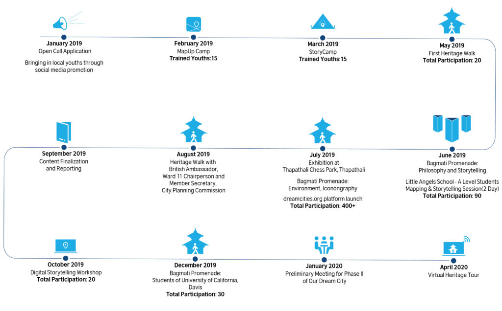
Our Dream City is a campaign design by StoryCycle that engage young people in the ideation, design and development of inclusive, sustainable and democratic cities spaces. It encourages youth leaders to take up an active role by using digital technologies, storytelling and the arts to engage their community and local civic processes to influence change and development practice.
In partnership with the British Council StoryCycle worked on the historic and culturally significant stretch of Bagmati River, from Thapathali to Teku, covering localities in Ward 11 and 12 of Kathmandu Metropolitan City. Under British Council’s 60 Years in Nepal celebrations, the project engaged young people and community leaders to produce narratives weaving together data and community responses that captured the of cultural, socio-political and historical identity of the place. Bagamati Promenade was first setting to the Our Dream City campaign.
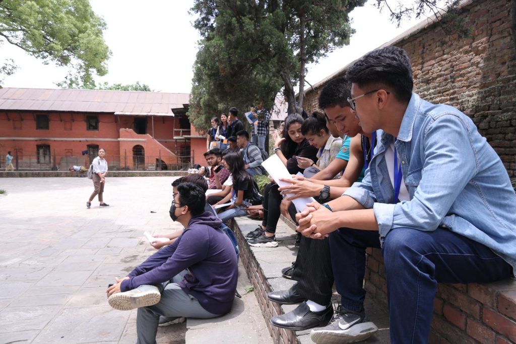
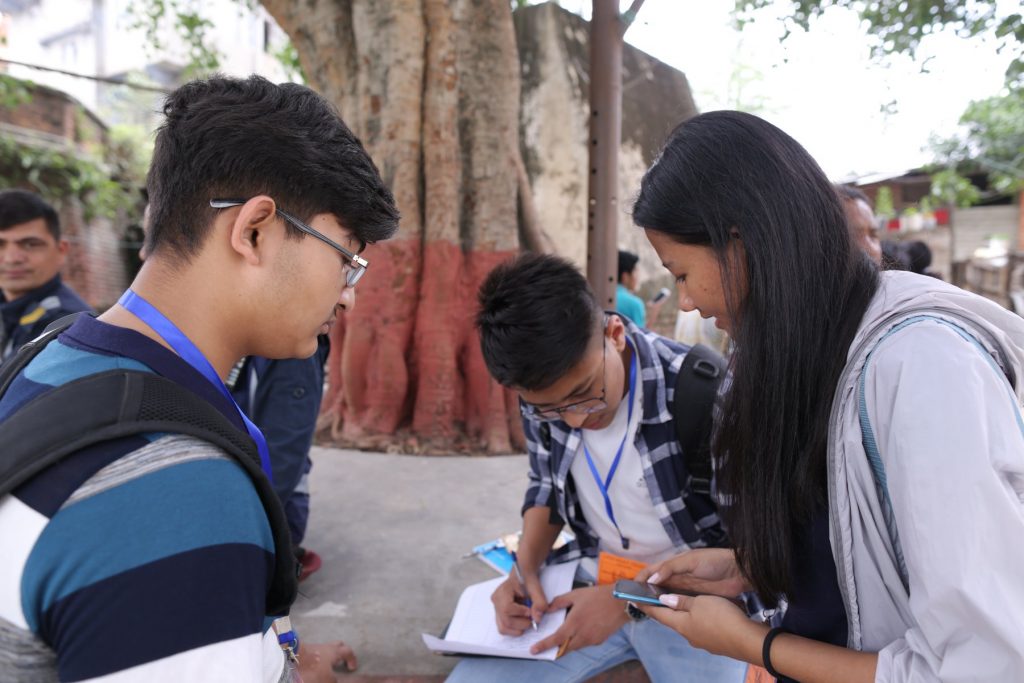
15 youths were select through an open call process to participate in a 3-day StoryCamp and MapUp Camp which were organized in collaboration with the local government. With workshop participants, ODC produced narratives documenting the Teku-Thapali stretch and its communities. 40+ sites were added to Google Maps and stories of 30 places were created and uploaded.
A-Level Students of Little Angeles(LA) School participating in mapping and storytelling session
The mapping and narratives then were used to develop thematic tours. Bagmati Promenade tours were designed catering to the demands for curated heritage walks that are now a preferred way of experience the rich cultural history of Kathmandu Valley. More than 400 people were reached over two months of tours that were led by heritage experts, engineers, architects, government officials, sustainable mobility enthusiasts, storytellers, cultural advocates and religious leaders.
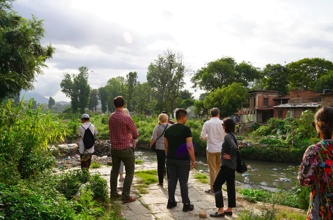
These tours were hosted with the aim of engaging wider public in discussions around current praxis of development that has not sufficiently accounted for the unique characteristics of the cities in Kathmandu Valley. It enabled those inhabiting the spaces along the site a platform to share their perspectives and concerns. The tours highlighted issues including competing visions from development projects, lack of leadership, illegal encroachment, environmental pollution, haphazard conservation approaches and other concerns. Essentially, the tours highlighted the hidden and unaccounted costs of exclusive development practices.
The event captured and shared information and stories of the various heritage structures along the pathway, highlighting the historic, cultural, architectural significance as well as the environmental impacts. It also brought along heritage enthusiasts, activists, stakeholders along with government bodies like City planning commission of Kathmandu Metropolitan City(KMC) and chairperson of ward -11 Hiralal Tuladhar who has been devoting his efforts in preserving and promotion of the heritage of Teku Thapathali stretch.
After concluding the first phase of activities, Story Cycle is currently engaging with City Planning Commission to develop additional content on the site. Longer-term goal for the project remains to influence development decision makers to create more holistic action plans that are inclusive of community concerns and youth engagement.
WoW Madhesh – Digital Storytelling Workshop
In October 2019, StoryCycle replicated the ODC workshops for groups of 10 youth in the cities of Birgunj and Janakpur. As part of the Women of the World Festival Madhesh (WOW Madhesh), the British Council support ODC to collect local data and narratives to champion gender transformative outputs. If you want more details, click here.
Virtual Heritage Tour
The World Health Organization (WHO) declared the novel coronavirus (COVID-19) a global pandemic. When Nepal government instituted lockdowns nationally, ODC took on a digital delivery approach to continue engaging a range of social actors in conversations about development and heritage. The Virtual Heritage Tour series followed the lead of Bagamati Promenade’s thematic walking tours and invited experts to lead home-bound viewers through locations inaccessible during the pandemic. To learn more about this monthly series, please click here.
Family of priests at Changu Narayan temple. He has been working for over 12 years in documenting rituals and other intangible heritages. Guiden us on how the iconography of religions help to depict the historical past and the present, as well as the future and the afterlife.
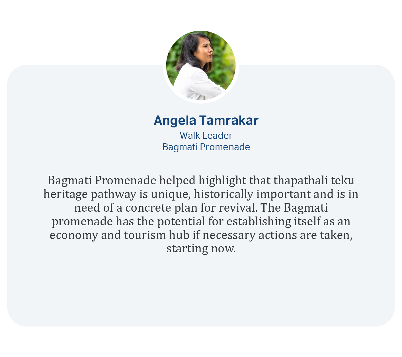
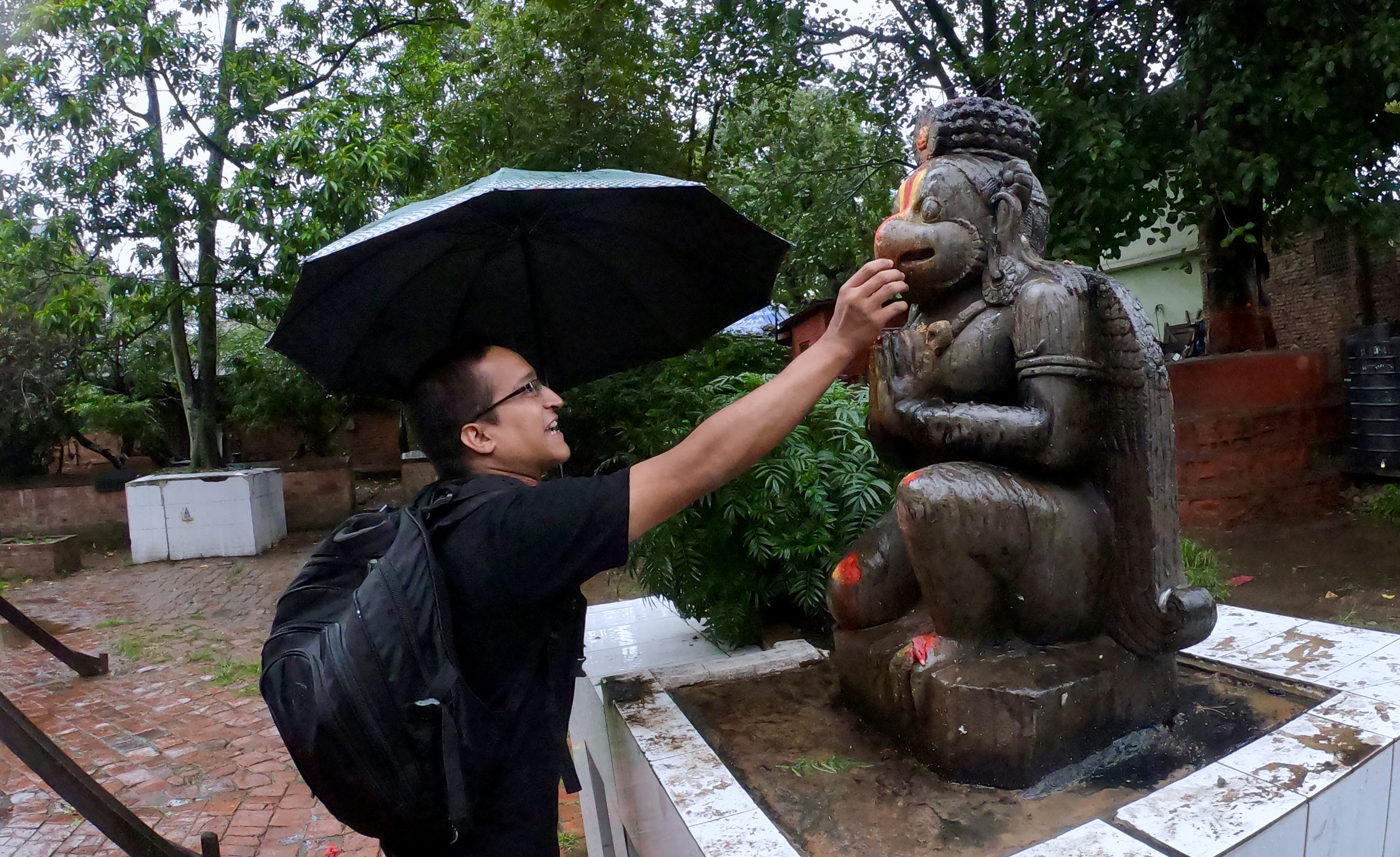
Iconography expert, Abhas Rajopadhaya led the walk with efforts to resemble the authentic information and convey the religious icons, visual images to the commuters. Walk conducted despite the heavy rainfall gave the essence of need for these sacred places to be away from the pollution.Religious icons are used to convey concepts concerned with humanity’s relationship to the sacred or holy and also to his social and material world. Other nonreligious types of icons achieved increasing significance in the 19th and 20th centuries, especially those dealing with human beings’ relationship to and conceptualization of the material world. Rational, scientific-technical icons have assumed ever-increasing importance in modern science and technology.
The emphasis on the depiction of historical past and the present, the cultural enthusiast found the walk the best on grounds with the walk leader turned the walk route to a mythical playground. The effort for awareness and realisation of the importance of these sites which bear great historical and cultural importance.
British Council Climate champion, Saurav Dhakal guided through the walk trail emphasising on the impact on natural and cultural environment of human activities.
The gruesome force towards ongoing development has transcended the boundaries and indeed built a road for us- one which led to morbidity. Unmanaged water-pipe/drainage and irrational human settlement takeover has abusively raised our thirst for the quality environment. The
walk has induced resonating force towards the importance of both tangible and intangible natural and cultural heritages with ongoing human evolution.
Sanjib Chaudhary is a communication expert and a Chemical Technologist who has led the Bagmati Promenade on the theme-Storytelling. He has guided through the stories associated with the places and the people across the Bagmati region all the way from Thapathali through Teku Dovan.
The periodical storytelling and authenticity driven by locals and mythical playground turned to the walking trail for the enthusiasts and heritage lovers. Depicting the core cultural values the avenue entails the historical background of several dynasties of Ranas, Licchhavis, Shahs. The art of storytelling broadened with the advent of technological advancements.
The walk on Saturday, June 29 was lead by Sushil Dhakal on the theme- “Mapping”. He has guided on how the Mapping and digitization of the archaeological sites is an important task to preserve cultural heritage.
Historical resources when presented properly will not only educate tourists but also the local community and helps in conserving it for future generations. Heritage Mapping is concentrated on discovering and experiencing the past in the present. And, this more practical when we get to engage in mapping and digitization of cultural heritage sites to preserve them.
High time the world being inclined towards the attraction of digitalisation, the force trying to bridge the gap with the digital and native world. Drone enthusiasts have come up with the inception of drone technology towards the 3D mapping for the primary data extraction to greater authenticity. Darpan Pudasaini, founder of Drone Nepal exclaims the need of accurate data for the further surveys and ensures with the technology assisting to extract the preliminary to monitoring data with 3D modelling from the aerial view. He ascertains the need for accurate data extraction for the heritage preservation to the policymakers, local community throughout the reconstruction to periodical tracking. Their promising attempt to help for the reconstruction with the technology sets a benchmark of youths’ assistance towards heritage preservation.
The next youth group with an idea to encourage people to walk collecting coins and a step forward to reduce carbon emissions. They have this app named “Walkman Green Coins” after the concept of rewarding walking commuters with the coins which can be redeemed into gifts and coupons. The team coming up with such an idea is set to merge the feature “Walkman Treasure” that scans the QR code and the information of the heritage pops out at which the user is scanning the code located. They have come up with this interactive idea to integrate the technology with scanning qr code to the information resource portal to which user finds relevant information regarding the heritage. These technological movements towards the preservation of heritage encourages more people to a common ground of vision to save the heritage for the future generation.
The very first heritage walk was led by Pushpa Raj Das. He is a senior leader(Mahant) at Udashi Akhada. An Akhada is a sampradaya monastery for religious renunciates in Guru-Shishya tradition. He has guided through the philosophical aspects associated with their Akhada, religion, norms customs and culture.
Philosophical amenities and the wisdom adds essence to the cultural and natural values. Insightful knowledge about the origin, periodic data and values shared around the aura during the walk induces the energy forces engaging on our efforts to preserve the remnants and exploration further.
एघारौँ शताब्दीमा अस्तित्वमा आएको राज्य हो, सिम्रौनगढ । हालः बारा जिल्लाको दक्षिणी क्षेत्रमा रहेको सिम्रौनगढ राज्य चौधौँ शताब्दीको पूवाद्र्धसम्म कला, संस्कृतिले सम्पन्न थियो । कर्णाटवंशी नान्यदेवले सिम्रौनगढलाई राजधानी बनाई राज्य स्थापना गरेका थिए । हाल यो क्षेत्र बारा जिल्लाको सदरमुकाम कलैयाबाट करिव २२ किलोमिटर दक्षिणपूर्वमा पर्दछ । यो गढ क्षेत्रभित्र कोटवाली, लक्ष्मीपुर, भगवानपुर, देवापुर, हरिहरपुर, कर्चोवा, अमृतजंग र गोलागञ्जसहित केही साना गाउँहरु पर्दछन् । यो किल्ला उत्तरमा कोतवालीहुँदै श्रीनगर, नयकाटोला, खजहनी, झमरीलगायत गाउँहुँदै दक्षिणतर्फ नेपाल भारत सीमासम्म पुग्दछ । यद्यपि, सिम्रौनगढ क्षेत्रले भारतको चम्पारन, मजफरपुर, दरभङ्गा, भागलपुर र पूर्णियालगायत जिल्लाहरु पर्दछन् । बारा जिल्लाले सिम्रौनगढ नगरपालिका नामाकरण गरेर इतिहासको सम्मान गरेको छ । सिम्रौनगढ राज्यको अन्तिम राजा हरिसिंह देव हुन् ।
शिखर शैलीको कङ्काली मन्दिर सिम्रौनगढको मुख्य बजार क्षेत्रमा रहेको छ । सो क्षेत्रकै प्रसिद्ध धार्मिक स्थलको रुपमा रहेको कङ्काली माईको मूर्ति केही खण्डित तर मर्मत गरिएको अवस्थामा रहेको छ । मन्दिरको भित्री भागमा रहेको काला पत्थर मूर्ति मूर्तिकलाको अनुपम नमूनाका रुपमा रहेको छ । सिम्रौनगढ राज्यमाथि १३ औँ शताब्दीमा भएको इस्लामिक आक्रमणबाट ध्वस्त भएको हो ।सुरुसुरुमा कङ्काली देवीलाई पशु बलि दिने प्रचलन रहेको थियो । पशु बलिपछि मन्दिर वरपर नै गाड्ने प्रचलन रहेको स्थानीय बताउँछन् । तुर्कहरुको आक्रमणपछि खण्डहर भएको सिम्रौनगढमा निकैपछि मानिसहरुको बसोबास हुन थाल्यो । त्यही क्रममा आएका मनसाराम बाबाले मन्दिरलाई व्यवस्थित गराएका थिए । सोही क्रममा उत्खनन् गर्दा राँगाका कङ्काल प्रसस्त मात्रामा पाइएको बताइन्छ । त्यही बेलादेखि नै सो मन्दिरलाई कङ्काली भन्न थालियो भन्ने भनाई रहेको छ । मनसाराम बाबा स्वयं वैष्णव भएकाले उनैले बलिको सट्टा सात्विक भोग चढाउने परम्परा चलाएका थिए । यस मन्दिरको पूर्वतर्फ प्राचीन घण्टा रहेको छ । सो घण्टामा लं.सं ११९ अर्थात् विक्रम सम्वत् १३४९ उल्लेख गरिएको छ । घण्टा केही टुटफुटको अवस्थामा देखिन्छ । सो मन्दिर क्षेत्रका ऐतिहासिक एवं पुरातात्विक महत्वका मूर्ति तथा वस्तुहरु यत्रतत्र छरिएर रहेका छन् । तिनको समुचित संरक्षणमा ध्यान दिन आवश्यक देखिन्छ ।
मनसाराम बाबाको समाधी/आश्रम:
कङ्काली मन्दिरको दाहिनेतर्फ इसरा तलाउ नजिक मनसाराम बाबाको समाधीस्थल रहेको छ । समाधी स्थललाई गुम्बज शैलीको मन्दिरभित्र संरक्षण गरिएको छ । जहाँ पहिला मनसाराम बाबाले अखण्ड धुनी बाल्ने गर्नुहुन्थ्यो । त्यही नै उहाँको समाधी गरिएको स्थानीय बताउँछन् । समाधीस्थलको केन्द्रीय भागमा केही उठेको जमिन देख्न सकिन्छ । त्यहाँ बाबाको खराउ समेत रहेको छ ।
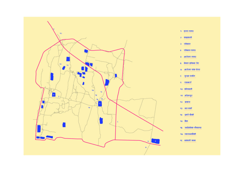
इसरा तलाउ
कङ्काली देवीको मन्दिरको पूर्वमा विशाल तलाउ रहेको छ । यो करिव आठ विगाह जमिनमा फैलिएको छ । यो तलाउ सिम्रौनगढका राजा शिवसिंह (सिबैसिंह) ले आफ्नी प्रेयसी इसराको लागि एक असुरले एकै रातमा तयार पारेको किंम्बदन्ती यहाँ प्रचलित छ । पोखरीको पश्चिम दक्षिण किनारामा १६ ह१९ ह ७ इन्चका इँटाले घाट निर्माण गरिएको छ । तलाउको पश्चिम तर्फको खुला चौरमा हाटबजार र छठमा मेला लाग्ने गरेको छ । देख्दैमा सुन्दर तलाउमा ठेक्काबाट व्यवसायिक माछा पालनसमेत गरिएको छ । यस्तो ऐतिहासिक तलाउमा ठेक्काबाट माछा पाल्नुभन्दा डुँगा सयर गराएर पर्यटकीय आकर्षणका रुपमा विकास गर्न सकिने सम्भावना रहेको छ ।
पार्वती मन्दिर
कङ्काली मन्दिर परिसरमा पार्वती मन्दिर रहेको छ । इसरा तलाउ नजिक रहेको यो मन्दिरभित्र कालो पत्थरको आकर्षक मूर्ति रहेको छ । तर, केही खण्डित मूर्तिलाई मर्मत गरी पूजाआजा गरिदै आएको छ ।
शिव मन्दिर
कङ्काली मन्दिर परिसरमा शिव मन्दिर रहेको छ । मनसाराम बाबाको मन्दिरकै लहरमा रहेको शिव मन्दिरमा तीनवटा शिवलिङ्ग लस्करै राखिएका छन् ।
विष्णु मन्दिर
कङ्काली मन्दिरको देब्रेतर्फ विष्णुको मूर्तिसहितको मन्दिर रहेको छ । मनसाराम बाबाको समाधिस्थलसँगै दाहिने घुँडा टेकेको र नमस्कार गरेको अवस्थामा विष्णुको मूर्ति रहेको छ । यो मूर्ति पनि केही खण्डित अवस्थामा छ ।
ईनार
कङ्काली मन्दिर परिसरको देब्रेतर्फ ऐतिहासिक ईनार रहेको छ । विष्णुको मन्दिरको दक्षिणतर्फ रहेको यो इनार प्रयोग विहीन अवस्थामा छ । यसको संरक्षणसहित खोज अनुसन्धान आवश्यक छ ।
भैरव
खण्डित अवस्थामा रहेको छ । स्थानीयहरु यो मूर्तिको खण्डित रुपलाई भैरव भन्ने गर्दछन् । यो मन्दिर कङ्काली मन्दिर परिसरमा इनारकै लहरमा रहेको छ ।
कङ्काली मन्दिरबाट करिव डेढ किलोमिटर पश्चिममा रनिबास मन्दिर रहेको छ । यो अलि उच्च स्थानमा रहेको छ । त्यस हिसावले सिम्रौनगढको राजाप्रसाद भएको सङ्केत गर्छ । यस मन्दिरका वरपर प्राचीन भग्नावशेषका साथै पुरातात्विक महत्वका सामग्री (माटाका खवटा, भाँडा, मूर्ति, मुद्रालगायत) पाइने गरिएको स्थानीय बताउँछन् । मन्दिरको पश्चिमतर्फको कुनामा (मन्दिरलाई घेरिएका सत्तलभित्रै) पुरातात्विक इनार समेत रहेको छ । त्यस्तै, मन्दिर प्रवेशको पूर्वतर्फको द्वारको दाहिनेतिर पनि पुरानो इनार रहेको छ । मन्दिर वरपर खण्डित मूर्तिहरु यत्रतत्र रहेका छन् । सो मन्दिरको पश्चिमतर्फ सुन्दर कमलपोखरी रहेको छ । पोखरी संरक्षणको अभाव देखिन्छ । पोखरीको छेवैमा रहेका धाराको केही अवशेष मात्र बाँकी छन् । शिकार खेल्न जाने क्रममा श्री ३ जङ्गबहादुर राणा सो स्थानमा पुगेका थिए । केही अग्लो स्थान भएकाले शिकार क्याम्प सोही स्थानमा बनाउने क्रममा दरबार र मन्दिरको भग्नावशेष पाइएको इतिहासविद्हरु बताउँछन् । शिकारकै क्रममा जङ्गबहादुर राणाको निधन भएपछि छोरा जीतजङ्गले बुबाको सम्झनामा राम मन्दिर निर्माण गराएका थिए । राम मन्दिरभित्रै राम सीताको मूर्तितिर फर्काएर जङ्गबहादुर र रानीहरुको मूर्तिसमेत प्रतिस्थापन गरिएको छ । मन्दिरको वरिपरी सत्तलसमेत निर्माण गरी गुठीको व्यवस्था गरिएको थियो । तुर्क आक्रमणबाट ध्वस्त सिम्रौनगढको उत्खनन् गरी सो मन्दिर निर्माणका क्रममा प्राप्त मूर्तिहरुलाई मन्दिरको बाहिरी भाग र वरपर स्थापित गरिएको बताइन्छ । मन्दिर बाहिरको चौघेरा सत्तलको दक्षिणतर्फको द्वारसँगै रहेको सिंहको अगाडि चालिस वर्षअघिसम्म एउटा शिलालेख रहेको स्थानीय बताउँछन् । त्यो शिलालेखमा नान्यदेवले राजधानी यही थलोमा बनाएको श्लोक कुँदिएको थियो भन्ने भनाई स्थानीय पाका व्यक्तिहरुको छ ।रनिबास मन्दिरको दक्षिणतर्फ हात्तीसार समेत रहेको छ । जीर्ण अवस्थामा रहेको यो हात्तीसार राणाकालीन समयमा निर्माण गरिएको थाहा पाउन सकिन्छ । भग्नावशेष अवस्थामा रहेको यो हात्तीसारको मर्मत गरी प्रयोगमा ल्याउन सकिन्छ ।
भवन
सिम्रौनगढ नगरपालिकाको निर्माणाधीन भवन । इशरा तलाउको दक्षिणतर्फ भवन बन्दै गरेको छ ।
हरिहरपुर
कङ्काली मन्दिरबाट करिव एक माइल पश्चिमोत्तर दिशामा हरिहरपुर गाउँ पर्दछ । यहाँ पुरातात्विक महत्वका भग्नावशेषहरु अहिले पनि देख्न सकिन्छ । केही अग्लो ढिस्कोमा विदेशी विज्ञहरुको सहयोगमा केही वर्षअघि पुरातत्व विभागले उत्खनन् समेत गरेको थियो । इँटहरुको पर्खाल देखिने ढिस्कोमाथि उत्खनन्को खाल्टो अहिले पनि रहेको छ । जहाँबाट कलात्मक ढुङ्गे स्तम्भ (थाम) भेटिएको थियो । जसलाई सोही स्थानमा प्रतिस्थापन गरिएको छ । स्थानीयले भनेअनुसार भक्तपुरमा स्थापित तलुजा भवानी हरिसिंह देव भाग्ने क्रममा यहिँबाट लिएर गएका थिए ।
हरिहरपुर क्षेत्रमा उत्खनन्कै बेला फेला परेको एउटा कलात्मक पत्थर रहेको छ । स्थानीयहरु त्यसलाई ढुङ्गाको बाकस वा तिजोरी समेत भन्छन् । वास्तवमा यो कुनै मन्दिरको ढोकाको ढुङ्गे सङ्घारजस्तो लाग्छ । यो ठाउँमा कतै खन्यो भने झुण्डका झुण्ड भँवरा निस्कन्छन् । त्यसैले यो स्थललाई तुलजा (तलेजु) भवानीको खण्डहर हो भनेर स्थानीयले भन्ने गरेका छन् । यो ढुङ्गाको बाकस चोरी गर्न आउनेहरुलाई नागले डसेर मारेका किम्बदन्तीहरु समेत स्थानीय सुनाउँछन् ।
खजहनी
यो गाउँ रनिबासबाट करिव एक किलोमिटर दक्षिणमा पर्दछ । कर्णाटवंशी राजाहरुले खजाना राख्ने ठाउँ भएकाले यस ठाउँको नाम खजहनी भएको जनविश्वास पाइन्छ । केही वर्षअघि एकजना किसानले कूलो खन्ने क्रममा एक मन जति सुन भेटेपछि त्यो लिएर भारत पसेको स्थानीय बताउँछन् । सो क्षेत्रमा माछा पोखरी खन्ने क्रममा केही न केही पुरातात्विक बस्तु तथा मूर्तिहरु अहिले पनि भेटिने गरिएको छ । खजहनी गाउँको वरपर विष्णु, शिव र दुर्गाका मूर्तिहरु पनि विगतमा भेटिएको स्थानीय बताउँछन् ।
सिम्रौनगढको उत्तरमा रहेको कोतवाली केही उच्चा स्थानमा छ । सिम्रौनगढको सुरक्षाका लागि माटोको अग्लो ढिस्को बनाइएको स्थानीय बताउँछन् । यो कोतको टुप्पाबाट हेर्दा सिम्रौनगढको वरपर देख्न सकिन्छ । यो करिव एक सय मिटर ब्यास र १५ मिटर जति उचाईमा रहेको छ । जनश्रुतीअनुसार कर्णाटवंशी राजाहरुको कोटपाल रहने भएकाले यो थुम्कोलाई कोतवाली भनिएको हो । यो ढिस्कोमा इँटा, झिँगटी र पोलेका माटोका ठूलठूला गोलाहरु पाइने गरेको स्थानीय बताउँछन् । पर्खालले घेरिएको यो थुम्कोको उत्तरतर्फ इनार रहेको छ । थुम्कोको पूर्वतर्फ शिवलिंगसहित उमामहेश्वरको खण्डित मूर्ति रहेको तर अहिले त्यो पनि हराइसकेको स्थानीय बताउँछन् ।
कङ्काली देवीको मन्दिर अगाडि इसरा तलाउ छ । त्यसको पूर्व दक्षिणतर्फ सिम्रौनगढको सुरक्षा घेराका रुपमा माटैमाटोको उच्च ढिस्को रहेको छ । यो उत्तर दक्षिण फैलिएको छ । यसलाई स्थानीयहरु तण्डुल पर्वत समेत भन्दछन् । सो स्थानमा खोस्रेर हेर्दा डढेको कालो चामल पाउन सकिन्छ भन्ने भनाई छ । यसरी डढेको चामलको क्षेत्र धेरैतिर फैलिएको बताइन्छ । रनिबास मन्दिर नजिकको प्रहरी चौकी निर्माणका क्रममा दुई फिट तल खन्दा समेत डढेको चामल पाइएको बताइन्छ ।